First Steps of Deep-sea Exploration.The beginning of deep sea exploration started with the calculation of Pierre Simon de Laplace in 1775, who gave an estimate of the average ocean depth by observing tidal motions on Brazilian and African coast. The calculated value of 3962m has been later proven very accurate by years of sounding measurements. But the nature of the deep ocean remained a mystery until the mid-19th century. The Challenger Expedition is probably one of the most well known millestone in the history of Oceanography and Deep-Sea Exploration. This sailing vessel that was redesigned into a laboratory ship covered 127,653 km. Sailing around the world from 1873 to 1876, this British scientific cruise realized 492 deep sea soundings, 133 bottom dredges, 151 open water trawls and 263 serial water temperature observations. The aim of this expedition was determined by the Royal Society as:
to be continued... |
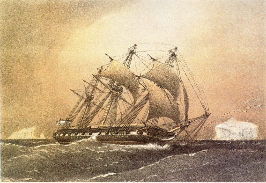
Painting of the HMS Challenger (1858), by William Frederick Mitchell.
|
From geosyncline to plate tectonics.One of the most important results of Marine Geology has been to illustrate the Plate Tectonic theory.
Until the mid-20th century, a majority of geologists were assuming that the Earth's major geologic features were fixed, and that large ocean basins and mountain ranges could be simply explained by vertical crustal movement, described in what was called the Geosyncline Theory. This theory was generally associated with the hypothesis of a contracting Earth due to heat loss over relatively short geological time. If this theory has recently been proven possible for small planets like Mercury, where the lithosphere forms a single tectonic plate (Byrne et al., 2014), in the case of the planet Earth, it has been replaced by the Plate Tectonics theory. In his book “The Origin of Continents and Oceans”, published in 1915, fifty years before the Plate Tectonic theory, Alfred Wegener was already announcing the idea of continental drift. He noted how the east coast of South America and the west coast of Africa looked as if they were once attached. This was the beginning of a long and vigorous scientific debate between “drifters” (geodynamical model) and “fixists” (fixed continents model), which last until mid-1950s. 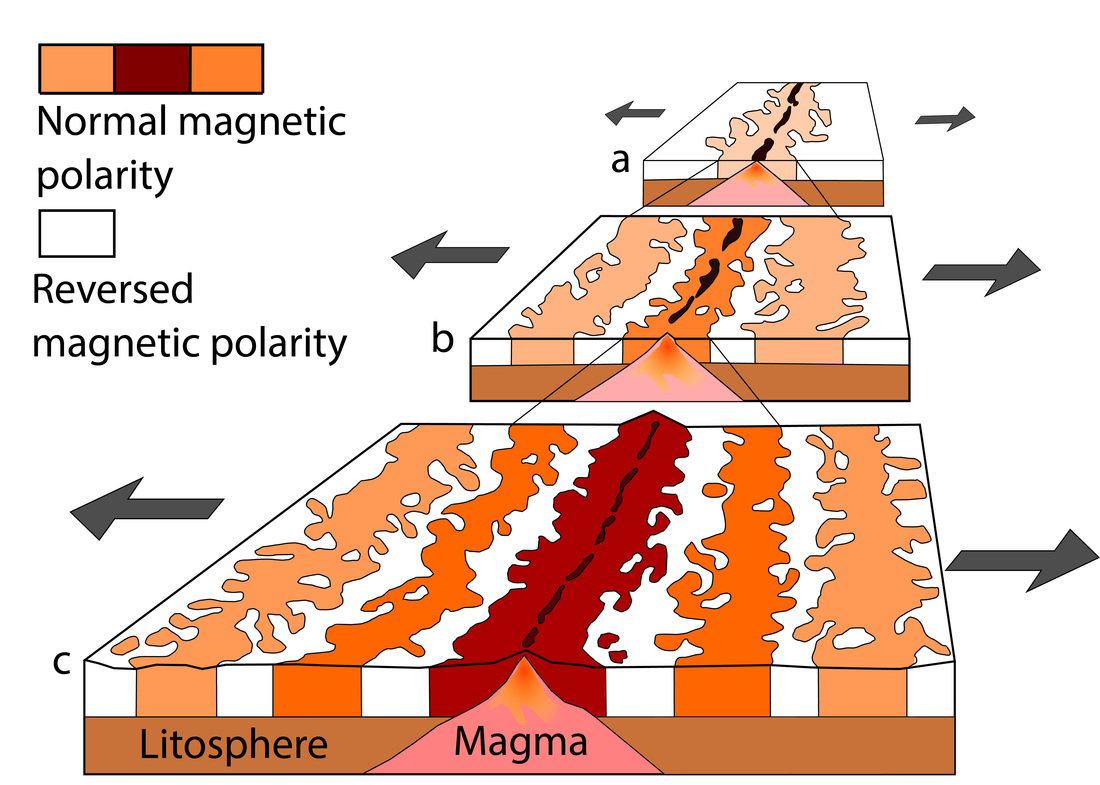
Theoretical model of the formation of magnetic striping:
a) the spreading ridge about 5 million years ago.
b) about 2 to 3 million years ago.
c) present-day.
|
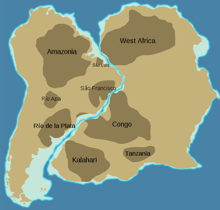
Paleo-reconstruction of American and African continent during the Triassic period, before the opening of the south Atlantic ocean.
Finally, the acceptance of plate tectonics theory by the majority of geologists came from new findings in marine geosciences: # The first piece of evidence came from an expedition led by M. E. Ewing in 1947 across the central Atlantic onboard the R.V. Atlantis. Using their instruments, they confirmed the presence of a large ridge approximatively in the middle of the Atlantic basin. They also found that the oceanic crust is much thinner than continental crust and is made of basaltic lavas and not granite, which is the main constituent of the continents. These discovery lead to the seafloor spreading theory. # The discovery of magnetic striping took place approximatively at the same period. In the beginning of the 1950s, scientists like Victor Vacquier, using magnetometers, began recognizing large magnetic variations across the ocean floor. When mapped over a larger area, these variations are forming a zebra-like pattern with bands of normal and inverse polarity. It is in 1963 that these magnetic data will be interpreted by Vine, Matthews and Morley as a record of the Earth's geomagnetic reversals, captured in volcanic rocks during the seafloor spreading. These data are at the origin of the paleomagnetic reconstruction of tectonic plates dynamic. |
Discovery of Life in the Deep Sea.
Rhizocrinus lofotensis, M Sars (1968)
|
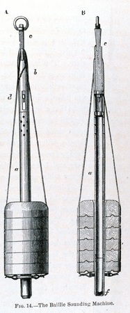 the Baillie sounding machine the Baillie sounding machine
In the early years of oceanography, the "Abyssus-Theory" stated that diversity of life in the deep sea is little and decreases with increasing depth. Following this idea, in 1843, Edward Forbes claimed that there could be no life in waters deeper than 550 m. In 1850, Michael Sars, a Norwegian theologian and naturalist from Bergen, disproved that hypothesis when he documented a diverse deep-water fauna at 800 meters depth outside the Lofoten Islands. This discovery was of critical importance for the development of deep-sea exploration since it motivated the British Government to send out the challenger expedition (see above). Before the development of submarine vehicles, observation of life in the deep sea was difficult and essentially conducted via towed nets, sounding and dredging. Nets of different size and mesh were the main tool for collecting living samples from different depths of the ocean aboard pioneer exploration vessels. In order to sample the seafloor life, sounding weight were used, like the Baillie sounding machine during the Challenger expedition. This sinker, built after the 1853 design of John Mercer Brooke, was used to measure the water depth. But it also had a tube below the weight that drove into the sediments. Another way to sample life forms at the surface of the seafloor was dredges. These metallic net shaped like bags were sweeping up biological specimens while being dragged across the bottom. |
If these oceanographic instruments brought a lot of new informations during the early years of deepsea study, exploration of the ocean made considerable progress with the invention of deep-diving submersibles. In 1930, W. Beebe and O. Barton reached a depth of 435 m (1430 ft) in the Bathysphere, where they observed jellyfish and shrimp. 30 years later, J. Piccard and D. Walsh reached the deepest known point of earth: the bottom of the Challenger Deep in the Mariana Trench. Descending to a depth of 10,740 m (35236 ft) in their deep sea vessel Trieste, they observed fish and shrimps.
A landmark deep marine bio-geology studies was carried out by scientists from Scripps Institution of Oceanography in 1977, when they observed for the first time hydrothermal vents on the Pacific Ocean floor near the Galápagos Islands.
to be continued...
A landmark deep marine bio-geology studies was carried out by scientists from Scripps Institution of Oceanography in 1977, when they observed for the first time hydrothermal vents on the Pacific Ocean floor near the Galápagos Islands.
to be continued...
A Submarine Arms Race (draft)Coming soon... from Bathysphere, deep-sea submarine to modern remotely operated vehicles.
In 1930, W. Beebe and O. Barton reached a depth of 435 m (1430 ft) in the Bathysphere. 30 years later, J. Piccard and D. Walsh reached one of the deepest known point of earth: the bottom of the Challenger Deep in the Mariana Trench, descending to a depth of 10,740 m (35236 ft) in their deep sea vessel Trieste |
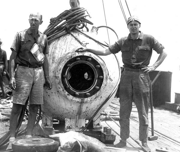
W. Beebe and O. Barton posing with the Bathysphere.
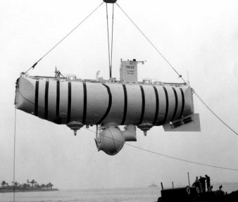
The deep-diving research bathyscaphe, Trieste.
|
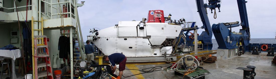
The DSV Alvin on the fantail of the R/V Atlantis following a dive.
